


KNOWLEDGE
How an Icelandic volcano helped spark the French Revolution
Profound effects of eight-month eruption in 1783 caused chaos from US to Egypt, say experts
- guardian.co.uk, Thursday 15 April 2010 18.11 BST
- Article history
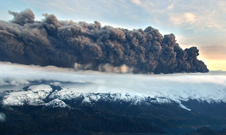
Just over 200 years ago an Icelandic volcano erupted with catastrophic consequences for weather, agriculture and transport across the northern hemisphere – and helped trigger the French revolution.
The Laki volcanic fissure in southern Iceland erupted over an eight-month period from 8 June 1783 to February 1784, spewing lava and poisonous gases that devastated the island's agriculture, killing much of the livestock. It is estimated that perhapsa quarter of Iceland's population died through the ensuing famine.
Then, as now, there were more wide-ranging impacts. In Norway, the Netherlands, the British Isles, France, Germany, Italy, Spain, in North America and even Egypt, the Laki eruption had its consequences, as the haze of dust and sulphur particles thrown up by the volcano was carried over much of the northern hemisphere.
Ships moored up in many ports, effectively fogbound. Crops were affected as the fall-out from the continuing eruption coincided with an abnormally hot summer. A clergyman, the Rev Sir John Cullum, wrote to the Royal Society that barley crops "became brown and withered … as did the leaves of the oats; the rye had the appearance of being mildewed".
The British naturalist Gilbert White described that summer in his classic Natural History of Selborne as "an amazing and portentous one … the peculiar haze, or smokey fog, that prevailed for many weeks in this island, and in every part of Europe, and even beyond its limits, was a most extraordinary appearance, unlike anything known within the memory of man.
"The sun, at noon, looked as blank as a clouded moon, and shed a rust-coloured ferruginous light on the ground, and floors of rooms; but was particularly lurid and blood-coloured at rising and setting. At the same time the heat was so intense that butchers' meat could hardly be eaten on the day after it was killed; and the flies swarmed so in the lanes and hedges that they rendered the horses half frantic … the country people began to look with a superstitious awe, at the red, louring aspect of the sun."
Across the Atlantic, Benjamin Franklin wrote of "a constant fog over all Europe, and a great part of North America".
The disruption to weather patterns meant the ensuing winter was unusually harsh, with consequent spring flooding claiming more lives. In America the Mississippi reportedly froze at New Orleans.
The eruption is now thought to have disrupted the Asian monsoon cycle, prompting famine in Egypt. Environmental historians have also pointed to the disruption caused to the economies of northern Europe, where food poverty was a major factor in the build-up to the French revolution of 1789.
Volcanologists at the Open University's department of earth sciences say the impact of the Laki eruptions had profound consequences.
Dr John Murray said: "Volcanic eruptions can have significant effects on weather patterns for from two to four years, which in turn have social and economic consequences. We shouldn't discount their possible political impacts." Greg Neale is founding editor of BBC History Magazine
In Vatnajökull National Park, in Western Skaftafellssýsla and near Kirkjubæjarklaustur, the historical Lakagígar are to be found.
Lakagígar is a magnificent 25 km long row of craters in Síðumannaafréttur. It stretches from the tuff stone cliff Hnúta, to the northeast through the tuff stone cliff Laki, which rises 818 meters, and ends in Vatnajökull. Laki stands approximately in the middle of the row of craters and from it there is magnificent view of the row of craters and the surrounding landscape. It is safe to say that the view of the area is spectacular, due to both unique nature and the history of Lakagígar.
Lakagígar became part of Skaftafell National Park in 2004. Skaftafell National Park then became a part of Vatnajökul National Park in June 2008. Lakagígar is considered one of the most remarkable geological remnants of the world. On June 8, 1783, one of the biggest lava eruptions of historical times began, and caused severely hard times in Iceland. The torrent of lava poured down the river-bed of Skaftá, filled the gorge of Skaftárgljúfur, which was thought to be 200 meters deep, and then spread out over the lowlands at Síða and a few farms. A lava branch flowed to the east along the mountains of Síðufjöll and stopped at a point, which is now called Eldmessutangi, over a month later, on July 20, 1783. The lava eruptions didn't stop there though. Just over a week later, on July 29, 1783, volcanic activity started again and then an eruptive fissure opened to the northeast of Laki. The torrent of lava flowed down the river-bed of Hverfisfljót, filled its gorge and spread out over Fljótshverfi. The eruptions stopped in February the next year, 1784. This is believed to be among the most amount of lava that has flowed on earth in historical times.
During the eruptions, large amounts of volcanic ash spread all over the country, though the layer of ash never became very thick. Following the eruptions, severely hard times followed in Iceland, known as Móðuharðindin. The nation suffered famine during the years of 1783-1786 which resulted in a population drop of 20%. It is also believed that 82% of sheep, 53% of cattle and 77% of horses died subsequently. Volcanic ashes and sour rain from the eruptions also spread further, reaching Europe and the whole northern hemisphere.
The Lakagígar row of craters stretches about 25 kilometers and the lava field of Skaftáreldahraun is thought to be around 565 km2 and 12 km3. It is believed to stretch around 60 km, but it's safe to say that these numbers don't give a complete or clear picture of the enormous mass of lava that flowed there. Magnificent history and beautiful landscape characterizes Síðuafrétt. Most of Lakagígar are today covered in woolly fringe moss, and it's worth to note that lava slag is loose, crumbles easily and the moss is very fragile. Therefore, tracks disappear slowly from it, making it all the more important to follow the rules of conduct, only follow marked paths, use the facilities at Laki and Tjarnagígur, and not drive off-road. There are five marked walking paths in the area, which was first proclaimed inviolate in 1971 and is extremely sensitive to intrusion. Travellers are therefore encouraged to seek information before entering the area.
The goal of proclaiming the area inviolate is to preserve this unique and fragile area. In light of recent discussions about nature preservation in Iceland, it is clear that there certainly is need for protection of historical and remarkable areas so that future generations will get to enjoy them as we do. An employee of Vatnajökull National Park is in Kirkjubæjarstofa, Kirkjubæjarklaustur, the whole year around. In the summertime, a park ranger in Laki provides tourists with information.
--------------------------------------------------------------------------------
--------------------------------------------------------------------------------
Lakagígar
Lakagígar, hraunrennsli
Hraunið í Lakagígum
© Snævarr Guðmundsson
--------------------------------------------------------------------------------
LAKAGÍGAR SKAFTAFELL NATIONAL PARK
25.2.2004
Lakagígar
Lakagígar, are a part of Skaftafell National Park. The area contains some of the world’s most remarkable geological formations while the plant and animal life is also of special interest. Because the area is very sensitive to encroachment, the aim of the conservation order is to preserve this unique and extremely sensitive area so that future generations can enjoy it in the same manner as we do now.
Park Ranger operate in the area on behalf of the Environment and Food Agency of Iceland.
Kári Kristjánsson, karik@ust.is
Office is at Kirkjubæjarstofa, Klausturvegi 2, 800 Kirkjubæjarklaustri
tel: 851-1946 - 822-4028
The Nature conservation division of the Environment and Food Agency publishes information brochures in English about Lakagígar
Geology
The Lakagígar eruption 1783 was the largest eruption since the settlement of Iceland and the accompanying lava flow (Eldhraun) was the third largest on earth since the last ice age1. Lakagígar (the Laki crater rows) were formed during 1783-1784. The name stems from the central peak in the area, Laki. Earthquakes shook the area for several days before the eruption began on Whit Sunday, June 8, 1783, with thunderous booms, ash falls and the stench of sulphur. The Lakagígar crater row sits on 10 parallel fissures, each of which is 2–5 km (1.5–3 miles) long. At the southern end of the crater row stands the mountain Hnúta, where the first fissure opened. The eruptions came in intervals generally accompanied by frequent earth tremors. During each eruption period, a new explosion fissure opened to the north of the existing sites of eruption. It is now thought that there was probably a total of ten periods of volcanic activity within these infamous eight months. Thus, there is a continuous row of craters on the volcanic fissure, with the largest crater in the middle. Around 135 craters were formed during the eruption period. During Skaftáreldar (“Fires of the Skaftá river”), a 200—500m (600—1650 ft) wide rift valley formed that stretched for 2 km (1.5) in a southwesterly direction from Laki, the valley is now hidden under volcanic gravel. Two fissures can clearly be seen on the slopes of Laki (818m, 2684 ft), in the middle of the crater row, towering 200m (656 ft) above the surrounding area.
The lava that flowed out of the Laki craters covers 0.5% of the area of Iceland. It flowed in two branches – Eldhraun, the western branch, and Brunuhraun to the east (see the accompanying map). The westerly lava flow poured out of fissures southwest of Laki, where the eruption started. The lava filled valleys and flowed over highland pastures in two channels. One of the channels filled Skaftá Gorge. The Skaftá River dried up on the third day of the eruption and by the fifth day, the lava had travelled 40 km (25 miles) and reached the coastal plain. By the end of July, the eruption subsided to the south of Laki but activity increased in the fissures to the north. A week later, the lava flowed down the course of the river Hverfisfljót, filling its canyon on the way. The river Hverfisfljót now follows a different course. Volcanic activity finally ended on February 7, 1784 – eight months after it had begun.
The question arises as to whether an eruption could happen again in the same fissure. Such an eruption would be very unlikely, but this is an active volcanic area and a new eruption could occur at another location in the area at any time.
Fact of Interest:
The lava flow was as much as 6000 m3 per second – several times the flow of Iceland’s most powerful rivers.
Questions Frequently Asked by Visitors
Why are there two colours of lava and gravel?
Red lava and gravel contain oxide (are rusted) while the black lava and gravel are not.
Why are the craters of different shapes and formed from different types of materials?
There were differing degrees of volcanic activity in the craters. The extent of fragmentation of the magma depended upon the rate at which magma released gases as it reached the surface and whether the magma came into contact with water. Slag from scoria craters is 5–10 cm (2 - 4”) in length while spatter cones are made up of pieces up to 1–2 metres (3–6 ft) across.
Where does the black sand come from?
The “black sand” is often called volcanic ash. It is both windborne and waterborne and often fills indentations, hollows and holes.
What did the area look like before the eruption?
The area from Laki north up to the glacier was covered in muddy river deposits, while to the south there were wetlands and green valleys.
Have there been other eruptions in the area?
Lambavatnsgígar, a broken row of scoria craters, lies to the northeast of Laki, but it is unclear when they last erupted.
Lava and Craters
There are three types of craters in the Lakagígar crater row: scoria cones, spatter cones and ash rings. All are tephra craters of differing sizes and shapes – some circular and others elongated. Scoria craters are the largest and most numerous, the highest rising 100m (300 ft) above their surroundings.
Most of the lava that came from the western branch of the fissures is block lava that is extremely broken and jagged, whereas the eastern branch is composed of the more even pahoehoe (or ropy lava).
Some Statistics
The volume of volcanic material here is tremendous – approx. 15 km3 (almost 2 cubic miles), of which 97% is lava and 3% is slag.
The area of the lava field is around 600 km2 (230 sq. miles).
The eruption released 400–500 million tonnes of gases.
The lava fountain is between 800 and 1400m (2500–4500 ft) and the column of ash is thought to have risen to a height of 15 km (9 miles).
If all the lava (15 km3) were made into a single cube, the cube would be 2.5 km long, 2.5 km wide and 2.5 km high (almost 2 miles long, 2 miles wide and 2 miles high).
The Flora and Fauna of the Lakagígar Area
The Eldhraun lava is almost completely vegetated all the way from the coastal plain up to the rims of the craters at a height of 650m (2130 ft). The area was barren of course at the end of the eruption, but now we can see a textbook example of growth succession: first lava, then moss, followed by grass, then shrubs, and finally trees.
The development of flora and fauna in the Lakagígar area has been influenced by volcanism, above average rainfall and a rather mild climate. Although rainfall is heavy, water seeps through the lava and slag very quickly and most plants have difficulty making use of it. Plant life characteristically consists of mosses and lichens. The moss in the Lakagígar area grows constantly, with new growth appearing on the upper part of the plant while the lower part of the plant dies and rots.
Growth of vegetation is slow and not sufficient to support mammal or birdlife, although a number of bird species visit the area to breed, including the snow bunting, wheatear, merlin (pigeon hawk), golden plover, purple sandpiper and meadow pipit. The red-throated diver (loon) breeds around the Lambavatn lake, which contains trout. Foxes are the only wild mammals living in the area.
Two particular types of habitat exist as a result of volcanism: The first habitat type is known as Breiskjuhraunavist in Icelandic, getting its name from the lichen Hraunbreiskja, which covers large areas of block lava – giving it a grey colour. However, mosses such as Racomitrium lanuginosum and Racomitrium ericoides are generally more apparent in this habitat. Racomitrium lanuginosum, a grey-coloured moss, is found particularly on the exterior slopes of craters and on mounds and ridges in the lava. Racomitrium ericoides, which has a more yellowish tint than Racomitrium lanuginosum, is widespread on slopes where snow collects.
More evolved plants are uncommon. One atypical area is the Eldborg channel, where many small flowering plants grow and bloom the latter part of summer. Least willow (Salix herbacea) is found and bracken and brittle bladder fern, which grow in hollows and ravines. The second type of habitat, Vikravist, draws its name from the pumice and ash that give the landscape a darkened hue. Vegetation is sparse and low-growing, affected by the continual shifting of the pumice. Nevertheless, a number of hardy species persevere in this habitat and characterize the vegetation. They are Alpine hair-grass (Deschampsia alpina), northern rock-cress (Cardaminopsis petraea), sea thrift (Armeria maritima) and Arctic fescue (Festuca richardsonii).
Frequent Questions from Visitors
How well is plant and animal life developing in the area?
Development is generally slow, although progress in the Eldhraun lava field is faster.
Volcanic activity has hindered the development of flora and fauna in Iceland for thousands of years and will certainly do so again and again.
Why does the moss grow more extensively on the Skaftáreldhraun lava field than on many others of similar age?
Heavy rainfall in this area, is conducive to good conditions for mosses and lichens. The climate is mild and the annual growth period is relatively long.
Why does moss change colour at different altitudes and degrees of dampness?
There are two species of moss: the grey Racomitrium lanuginosum), which grows at higher altitudes on crater tops and lava peaks, and the yellowy Racomitrium ericoides, which is predominant in lowland areas.
Mosses change tint to a substantial degree when wet.
History
The devastation that accompanied Skaftáreldar (“The Fires of the Skaftá River”) in 1783-1784 represents the single most catastrophic event since human settlement in Iceland. Poisonous ash settled in almost every part of the country and polluting gases hung in the air. The rank atmosphere gave the period its name – Móðuharðindi (“Hardships of the Mist”). Black clouds of ash descended onto the coastal plain bringing darkness. Footsteps became imprints in the ash. The ash poisoned pastures and livestock starved.
As winter progressed, more and more animals succumbed to hunger or to volcanic poisoning.
With no vegetation and dwindling meat supplies, a large part of the human population consequently died from hunger.
Yet the troubles became even worse. As a result of the dense clouds, the weather grew colder and ice gathered along Iceland’s shores. Help from the Danish king, who was the colonial ruler of Iceland, arrived late because reports did not reach Copenhagen until autumn. A ship of provisions left Denmark in November, but it was not able to reach Iceland until the following spring. Distribution of the supplies did not go well because both Icelanders and their animals were in a weakened condition. The situation was so bad that the King of Denmark even considered transporting the remaining Icelandic population to the Jutland area of Denmark.
Two years after the eruption, the stock of cattle had been halved, the number of horses was reduced by two-thirds and only one-fifth of the sheep flock had survived. One in five Icelanders died during the “Hardships of the Mist” – around 10,000 people.
Two of every five people died in the close vicinity of Laki; 20 farms were completely engulfed by lava and a further 30 became inoperable for a period of time.
“The Sermon of Fire”
On Sunday, July 27, 1783, Father Jón Steingrímsson held a service in his church in the small village of Kirkjubaejarklaustur. A month and a half had passed since the eruption began. Father Jón considered the eruption a punishment from God for debauchery, laziness and other sinful living. The eruption was still at its peak – the lava flow was speedily heading towards the village, and the thunderous rumblings and crashes undoubtedly magnified the terror of the villagers.
Father Jón called to God, promising that the congregation would repent their sinful ways. The lava flow reached the Skaftá river at a rock called Systrastapi, just outside the village.
And there it stopped. Father Jón’s compelling prayers and address to God is now known as the “Sermon of Fire”.
The Effects of the Skaftáreldar Eruption on Other Countries
The sulphurous cloud from the eruption gradually spread across most of the northern hemisphere, affecting the climate across a wide area.
Two days after the onset of the eruptions, the cloud of gases had become a mist that reached the Faroe Islands, Norway and Scotland. By the middle of June, it spread across mainland Europe.
By June 24, a black mist hung over all of Europe, reaching as far as Finland and covering countries as distant as the Balkans. The European press portrayed the sun as a blood-red disc at sunrise and sunset. They wrote that the midday sun shone so dimly that people could look at it directly with the naked eye.
By July the mist had reached Russia, Siberia and China. At its peak, it covered one quarter of the earth’s surface – all of the land north of latitude 30°N. (See map).
After Iceland, the ecological effects of the mist were felt most in the other Nordic countries,
Western Europe and the British Isles, causing crop failures. The acid rain defoliated trees and withered smaller plants. The overall temperature dropped by 1.3 °C (2 °F). The cold spell lasted three years with harmful effects reaching around the world. The mist penetrated even the farthest parts of the planet. As quickly as the very summer of 1783 there was a serious failure of Japan’s rice crop caused by cold and wet weather, resulting in the worst period of famine in Japan’s written history. Similar stories came out of Alaska, where entire townships died out.
The French Revolution marked a turning point in the evolution of republicanism and civil rights.
One theory suggests that the French Revolution had its roots in Laki, when, as previously mentioned, the effects of the mists had altered weather patterns across Europe.
Access to Lakagígar
The road to Laki leaves the Ring Road at Hunkubakki. It is a mountain road and vehicles must cross (ford) unbridged rivers that swell in heavy rain. Proceed with caution.
The Laki Circle road, passes Galti, and continues to Laki, Blágil and over Eldhraun, reaching Eldborg at Hnúta. The road is reasonably passable from the highway as far as Tjarnargígur, but the part from Tjarnargígur to Blágil is a rough track suitable only for 4-wheel-drive vehicles.
As in all other areas, driving off designated roads and tracks is forbidden and visitors are sincerely requested to comply with this regulation so as to keep this extremely sensitive environment intact for future generations to enjoy as well.
The conservation area is open to visitors throughout the year but access may depend on weather conditions. The road is officially closed during the period of thaw in the spring. It is usually open from the middle of June.
White Trail (20 minutes). This trail leads into a crater southwest of Laki.
In the bottom of the crater is a small cave that was once connected to another cave that passes under the road. This is the collapsed opening of the lava channel leading out from the crater.
Tjarnargígur – Eldborgafarvegur Trail (2 hours). From the car parking area, this easy footpath leads into Tjarnargígur crater and then through a large area of craters it reaches a second large crater. Take the same path and return to the parking area. There are numerous points of interest along the way. This is an easy path.
Accommodation
Camping is not allowed within the Laki area. There is a good camping area at Blágil, (a 40-minute drive from Laki), with spring water and toilets.
There are mountain cabins at Blágil and Hrossatungur, where basic accommodation is available at reasonable prices. Employees at the Skaftárhreppur Parish Council offices see to bookings of the huts.
Rules of Conduct
Lakagígar is an extremely sensitive area. The gravel is very loose and will crumble at the least disturbance. Moss is very delicate, and every footstep leaves a long-lasting mark. Please keep to marked trails – this is the best way you can help us conserve this magnificent area.
Skaftáreldar (“The Fires of the Skaftá River” eruptions) released around 120 million tonnes of sulphur dioxide (SO2) into the atmosphere during a five-month period, of which 100 million tonnes were churned up in the lower stratosphere (10-15 km/6-10 miles high) where the sulphur dioxide combined with water vapour (H20) to form around 200 million tonnes of sulphuric acid vapour (H2SO4). During the summer and autumn of 1783, upper atmospheric winds dispersed the acid as a mist over most of the northern hemisphere.


